 |
 |
|||
|
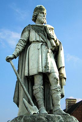
Alfred’s birth in Wantage is remembered by his huge statue sculpted by Count Gleichen, and erected in the centre of the market-place. It can be viewed as a slightly smaller version of that standing in his capital at Winchester. In Wantage, Alfred’s scholarly pursuits are emphasised, for in his left hand he holds a scroll, reminding us that the King preferred the might of the pen to that of, in this case, the axe, in his right hand. King Alfred's School is in the town and two of the local pubs remember him: The Alfred's Head and the King's Arms. There is little, if any, trace of the Danish encampment at Reading left to see. It would have been around the eastern end of the Forbury Gardens, the area later occupied by Reading Abbey Church. It would have been an ideal defensive site near where the two rivers join at its western end. The River Kennet to the immediate south and the marshy lands leading down to the Thames not far to the north would mean only the east had no natural defence. The same spot was identified as a safe haven centuries later when King Stephen built a castle there. The Blowing Stone stands next to the old inn, now a private cottage, just off a cross-roads on the B4507 between Wantage and Ashbury. North leads to Kingston Lisle where a more modern 'Blowingstone Inn' stands, but turn south instead. Before ascending Blowingstone Hill, the cottage and stone can be found on the left. The stone is protected by a small fence, but visitors are invited to attempt to sound it in return for a small donation to charity.
These days the accepted battle site is thought to have been somewhere along the Ridge Way at the other end of the Downs, probably near where the parish boundaries of Blewbury, Aston Upthorpe, Aldworth and Compton converge. Colonel Burne suggests a site in the parish of Aldworth just south of this spot, where the bridleway from Aston Upthorpe to Compton crosses the Ridge Way. Thorn-trees still grow there. The parish church of Aston Upthorpe, where King Ethelred supposedly stayed at his prayers, can be easily found (in Thorpe Street) in the centre of the village which lies just north of the A417. The place has more or less merged with Aston Tirrold whose alternative venue, complete with Saxon square-headed doorway, stands in nearby Aston Street. The supposed burial places of the defeated Danes are scattered all over the Downs. Wayland’s Smithy sits quietly beside the Ridge Way. Parking is provided off the B4000 just below Ashbury, then there is a short walk to take along the Ridge Way. The Burial chamber is to the left about a mile away. The Seven Barrows sit in a valley north of the village of Lambourn. They can be easily seen from the road between the village and Kingston Lisle, which goes over Blowingstone Hill and past the Blowing Stone itself. The sarsen stone memorials to the rest of the dead are scattered in front of Ashdown House. They can be viewed from the B4000. Letcombe Regis and Letcombe Bassett lie south-east of Wantage. Take the first road on the left off the B4507 out of the town. The Royal village comes first, with the Bassett a bit further up the valley. Ambarrow Hill stands next to the A321 between Sandhurst and Crowthorne. It is National Trust property, and adjoins the grounds of, the now demolished, Ambarrow Court, an area of natural beauty belonging to Bracknell Forest Borough Council. There is free access for the public to both. Edgebarrow is just off the A3095 which runs parallel with the A321 into the other end of Crowthorne. The field known as Battlingmead is now a residential road of the same name, just south of White Place, off the A4094, running north of Maidenhead. It is down by the river almost opposite Taplow Hospital. There is nothing to see now of Abingdon Abbey Church except a mock ruin in the Abbey Gardens made from some of its architectural remains. The Gateway and Exchequer building are much more rewarding, but are much later than the 9th century. Serpen Hill lies a quarter of a mile east-north-east of the town.
Cherbury Camp lies in the parish of Charney Bassett, just west of the road running due south from the A420 and into the village. A footpath leads around the camp from Lovell’s Court Farm to Charney. Eddington is that part of Hungerford north of the River Kennet surrounding the A338 running up to the M4 (Junction 14). The river crossing here would be Hingwar’s ford. This is not to be confused with the crossing of the Kennet and Avon Canal further south in Bridge Street. The so-called Saxon memorial stone in Bourton stands in the middle of the village on the village green. The people of Hungerford can be observed celebrating Hocktide every second Tuesday after Easter. The ceremonies are rather complicated, but basically there is the sounding of John O’Gaunt’s Horn, the holding of the Hocktide Court in the Town Hall, and then the touring of the town by the Tutti-Men. The "Orange Man" dressed in top-hat and tails parades the High Street collecting kisses from all the ladies leaning from the windows of each commoner’s cottage. Everyone receives an orange in return. This is probably related to the usual binding and forfeits for men. The Orange Man is accompanied by two "Tutti-Men" with their flower-festooned tutti-poles who sometimes have to help him in the most extraordinary manner with ladders and the like. Finally the events of the day are rounded off with a traditional Tutti-Supper at the Corn Exchange and the drinking of the Hocktide Punch. Wallingford still retains the huge earthen banks of its Burgh surrounding the town. The northern section is particularly well preserved, though the north-eastern portion is obscured by the remains of the castle. The north-western area within the earthworks is still as bare as it was in Alfred’s day. The banks so impressed Victorian historians that many believed they were too great a feet of engineering for the Saxons, instead preferring to ascribe them to the Romans, claiming Wallingford as the town of Calleva Atrebatum (now known to be Silchester in Hampshire). Sashes is less impressive, and since the name has now disappeared, it has only relatively recently been identified. It is the large island, now called Odney, within the huge bend in the River Thames and the Lulle Brook at Cookham. It is now cut through by an artificial channel containing Cookham Lock. It is an extremely pretty spot that can be reached via a footpath running on from Odney Lane opposite the end of Cookham High Street. Back
to: Alfred and Ashdown
|
|||
| © Nash Ford Publishing 2003. All Rights Reserved. Many of these locations are now administered by Oxfordshire County Council. | ||||

 King
Alfred & Ashdown
King
Alfred & Ashdown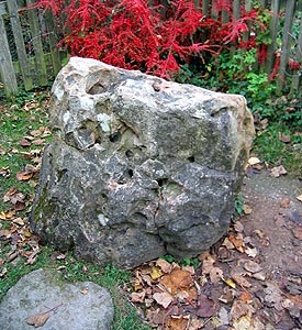 Two
of the camps where the foes met before the battle of Ashdown are very close
together.
Two
of the camps where the foes met before the battle of Ashdown are very close
together.  King
Alfred’s Palace in
King
Alfred’s Palace in